Drones for Land Surveying
Photogrametric and LiDAR drones! We can combine BOTH technologies to maximize the accuracy of both and save time and turn-around time.
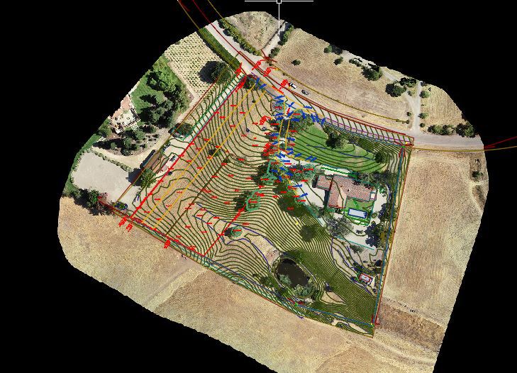
With our state-of-the-art drone, that has RTK onboard, and a D-RTK 2 base station, we can map ground data at a 0.1' level accuracy! This is a great tool for surveying projects like topographic mapping. If you have a project, where there isn't heavy tree canopies, and tall grass, then we should be able to use our drone to keep costs down vs. traditional methods of topographic surveying. We can produce a color ortho-photo, contours, and linework.
We will also be able to combine the data into one drawing if some features require a higher degree of accuracy that what the drone can provide, but use the drone for features like contours, fields, surrounding grades, roof top grades and imagery.
commercial site. Solvang, CA.
Give us a call, or email us for a free quote!
Projects that are good for a drone survey:
Vineyards
Farms
ADU and landscape design surveys
Topographic Surveys
Project best left to conventional methods:
Heavy tree and vegetation canopies
Dense, tall grass
Downtown skyscraper areas
Restricted airspace (such as near airports) It's not impossible but they tend to take many weeks to get approval
ADA or Access (Handicap) design surveys
Building footprints needed for an addition. We can supplement a drone survey with an on-the-ground survey however.
500 acre plus ranches should be flown using traditional photogrammetric methods since the cost differences start to break even.
Small lots aren’t ideal unless you need to obtain adjacent grades well beyond the perimeter of the subject property.
Other considerations will be evaluated on a case-by-case basis.
Eric J. Ackerman, PLS is a Certified Federal Surveyor No. 1609.
Eric is licensed in California, Arizona, Idaho, Nevada, and Colorado.
CA LS 8226
AZ RLS 69068
ID PLS 18767
NV PLS 26941
CO PLS 38714
UT PLS 2201
Licensed Drone Pilot
ALTA Surveys
Elevation Certificates/ Flood
Contact Us
To contact us, just call
(805) 691-9112 or complete the
email: proposals@gromatici.com
Los Olivos: 805-691-9112
2432 Railway Ave., Suite I
Los Olivos, CA 93441
Santa Barbara: 805-845-2133
Atacadero: 805-464-2592
Current Projects
Click here to find out what projects we are currently working on.
Helpful Links
Links to research and information. Click here
Member of the Arizona Professional Land Surveyor's Association.

Member of the Santa Barbara Contractor's Association.
